
Story By Steve Scauzillo | San Gabriel Valley Tribune
In Solomon-like fashion, President Barack Obama split the heavily used Angeles National Forest in two, placing one half inside a brand-new San Gabriel Mountains National Monument while leaving out the other half.
Exactly three months after the historic designation, some are questioning the president’s wisdom as nonprofits, environmental groups, federal, state and local agencies grapple with a confusing arrangement that baffles even proponents and leaves an inequitable division of haves and have-nots.
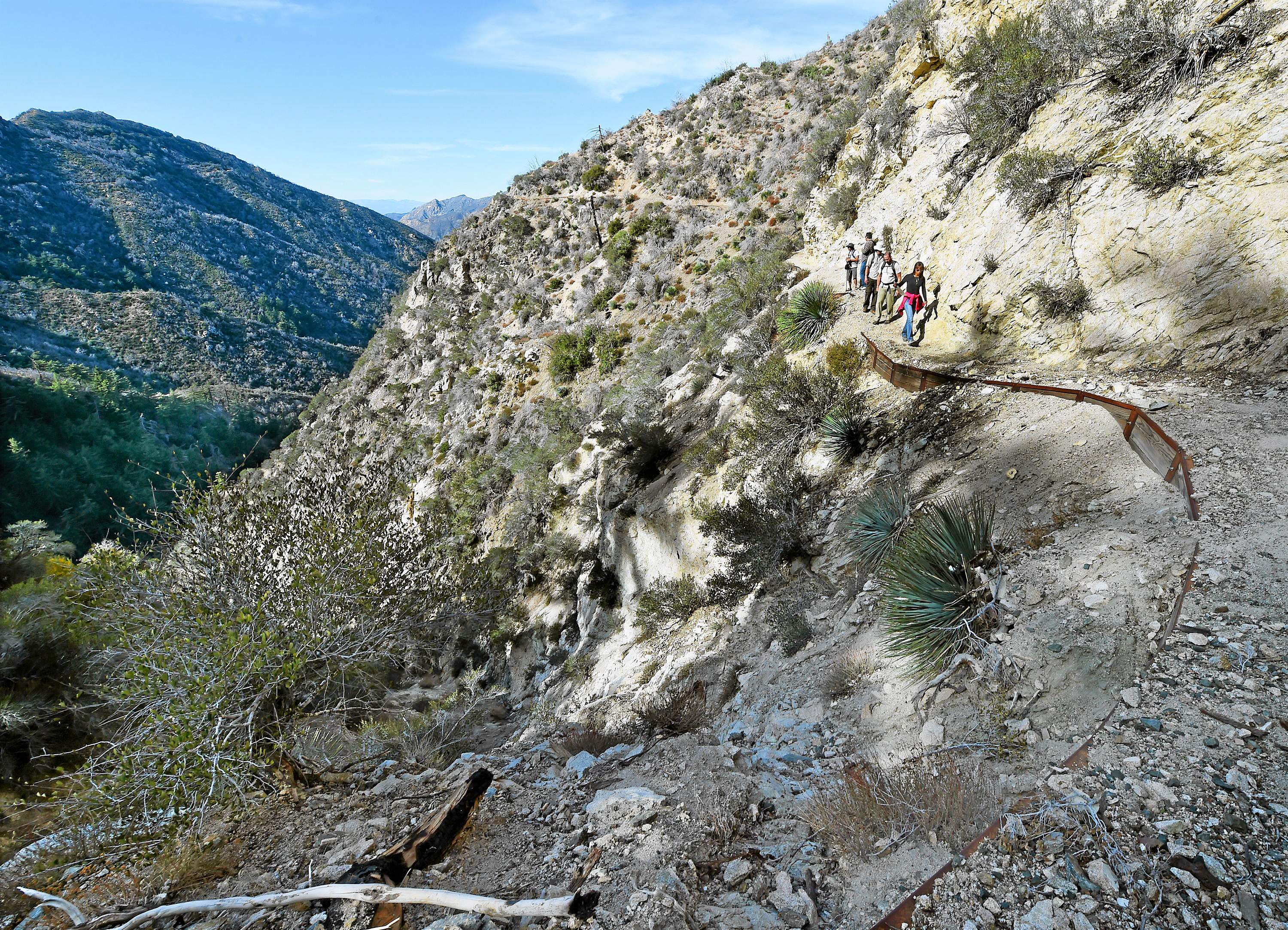
For example, when asked to state the size of the monument, three heads of nonprofit groups working in the 700,000-acre Angeles — which stretches from the San Fernando Valley to Mt. Baldy — each gave wildly different answers. Just locating the boundary when driving rock-pitted fire roads or trekking up 5,000-foot elevation trails overgrown with poisonous weeds became a difficult task.
“From my perspective, we consider it an invisible line,” said Eagle Rock resident Steve Messer, president of the Concerned Off-Road Bicyclists Association and a member of the national monument collaborative committee.
Groups such as CORBA, the Los Angeles Conservation Corps, the San Gabriel Valley Conservation Corps and the National Forests Foundation say the monument is a positive effort that will stoke the donor community but won’t affect their work. They will continue to repair trails, rip out invasive weeds and plant trees both within the monument and non-monument area, saying they can deal with whatever new bureaucracy is thrust upon them by the presidential designation.
Those representing areas left out of the monument are not as sanguine. They feel slighted and are calling for an expansion of the monument boundaries by Congress or the president. These include the collective of environmentalists, ethnic minority groups, labor and clergy called the San Gabriel Mountains Forever and Rep. Judy Chu, D-El Monte, the lead legislator in the monument effort, who behind the scenes are working to expand the boundary.
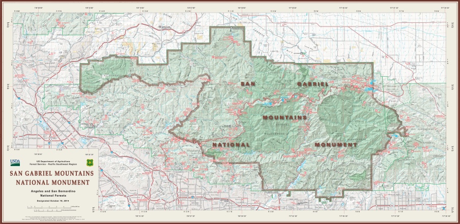
But the strongest voice for expanding what the White House web site describes as a 346,177-acre monument mostly situated in the eastern portion of the Angeles is the Arroyo Seco Foundation Managing Director Timothy Brick. Brick has written the president and the mayor of Los Angeles for help.
“The areas cut out are at least as important or more important than the areas included in the monument,” Brick said Wednesday during an interview.
During a meeting of stakeholders in Chu’s office a month after Obama’s visit to Bonelli Park in San Dimas, all agreed the monument deficiency should be remedied. But a lobbyist for Chu said she had heard back from Obama’s people that there was far too much grumbling about the national monument boundary from groups who wanted their parts of the forest included, presumably to draw more federal funding for long-sought trail re-openings and additional forest rangers.
“They (White House) thought they would only get positives out of it,” said Brick, a Pasadena resident, long-time environmental activist and former president of the Metropolitan Water District of Southern California.
The zigzagging SGMNM leaves out the Mt. Wilson Trail but includes the Mt. Wilson Observatory. Much of the heavily used front-range above Pasadena and Altadena, often cited by Chu as a reason for establishing a broader National Recreation Area but then settling for the smaller national monument, were cast outside the boundary. Left out also was the heavily used Chantry Flat hiking and picnic area above Arcadia, including Hermit Falls where young people using social media jam trails and sometimes dive into shallow pools at great peril, some ending up dead or paralyzed.
Also removed was Big Tujunga Creek, a major source of Los Angeles water.
In the east boundary, Cucamonga Canyon, another extremely popular hiking area that this past summer burdened the Rancho Cucamonga Fire Department with numerous rescue calls, was left out. This despite calls from the fire chief and a vote from the City Council.
Already, the National Forests Foundation have committed $3 million toward improvements within the monument. The U.S. Forest Service published a list of “monument projects” including restroom repairs, road repaving and $555,000 toward Chilao, Mt. Wilson and Scenic Byway Wayside interpretation centers. Already, the USFS announced it spent $300,000 on eight youth crews to clean up visitor sites in the monument.
Meanwhile, most of the Arroyo Seco damaged by fire but outside the monument remains the same, Brick said. Portions of the historic Gabrielino Trail wrecked by mud flows remain closed, he said.
“The upper Arroyo territory has been virtually untouched. Nothing has been done to fix the damage done there,” Brick said.
The most obvious portion cut out of the monument is the 161,000 acres torched by the 2009 Station Fire, the largest fire in Los Angeles County history, which took the lives of two firefighters, Capt. Ted Hall and Specialist Arnie Quinones, and destroyed 209 structures including 89 homes in La Cañada Flintridge, Altadena, Acton, Littlerock, Sunland and Tujunga.
In 2010, heavy rains brought vicious mud slides that covered picnic areas four-feet deep in mud and reduced pine and oak-covered slopes to naked soil.
Brick argues the Station Fire area should be Job 1 on the president’s and U.S. Forest Service’s list for restoration. None of the burn areas in Sunland-Tujunga or the Arroyo Seco are included in the national monument.
In fact, Chu and environmental groups originally thought a larger area was included in the monument but that changed the day of the designation, shocking many proponents. A large bite had been taken out of the monument map — the southwestern part of the Angeles.
“It is striking to note that much of the area excised from the final National Monument map coincides with the area destroyed by the Station Fire,” said Brick, who claims the U.S. Forest Service didn’t want to deal with such a thorny problem.
Brick received sympathy, even support, for expanding the monument boundaries from Los Angeles Mayor Eric Garcetti. Garcetti sent him a letter saying the solution could be found with Rep. Adam Schiff, D-Burbank, who has commissioned a Rim of the Valley National Recreation Area study that could create a unit of the U.S. National Park Service that would include the omitted portions of the Angeles above Pasadena, Glendale and the eastern San Fernando Valley, as well as the Santa Susanna and Verdugo mountains.
Unfortunately, the final draft expected in October, and again in December, has been delayed. Sources say the reason is the complications brought by the creation of an adjacent national monument.
A collaborative committee is meeting today to prioritize spending on the San Gabriel Mountains monument and decide what other groups should be involved in decision making.
“We’ve let the people at the USDA (the Department of Agriculture oversees the Forest Service) know we would like to see the boundary expanded,” said Belinda Faustinos, vice chair of San Gabriel Mountains Forever.
Most have ruled out going through Obama for another bite of the apple. The other option is to re-jigger Chu’s National Recreation Area bill which includes a much bigger boundary that also takes in the San Gabriel River and part of the Puente Hills.
Chu, who has not said officially she is pushing for expansion, indicated in a statement she intends to re-introduce her San Gabriel National Recreation Area bill, which could supercede the president’s proclamation — if adopted by Congress and signed by the president.
There’s talk of putting new language in her bill that would amend the national monument boundary to include Big Tujunga and historical front-range forest trails.
“Oh sure, those (additional forest lands) are the things under consideration,” Faustinos said.
Daniel Lovato, deputy supervisor of the Angeles, said the president’s monument shone a spotlight on the needs of the entire Angeles, which sees 4 million visitors a year. Some foresee an overflow effect since both areas are managed by the U.S. Forest Service.
“Regardless of whatever boundary, it is still part of the Angeles National Forest,” he said.
Read the full article at San Gabriel Valley Tribune
ABOUT THE AUTHOR
Reach the author at Steve.Scauzillo@sgvn.com or follow Steve on Twitter: @stevscaz

